
Route of the Volcanoes: La Palma’s great ridge hike
From Refugio El Pilar onto Cumbre Vieja
The Route of the Volcanoes follows the southern GR-131 along the Cumbre Vieja ridge and is one of La Palma’s most impressive but demanding hikes. It starts at Refugio El Pilar, a broad forest clearing that has been a crossroads between the island’s eastern and western slopes for centuries. The trail first climbs through Canary pine forest.
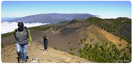
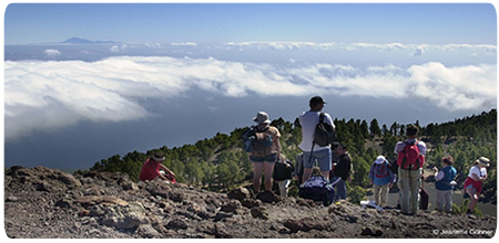
Above the forest, both sides of the island come into view. Mazo, Santa Cruz and, in clear air, Tenerife and La Gomera lie to the east; the Aridane Valley, Cumbre Nueva and Caldera de Taburiente spread out to the west. Trade-wind cloud often spills over the crest and dissolves down the drier western slope like a slow cascade.
Craters, eruptions and the highest point
The route links a long chain of volcanic forms: Birigoyo, the dark Hoyo Negro crater, Duraznero and the two summits of La Deseada. At 1,932 metres, Deseada II is the highest point. From here it becomes clear that Cumbre Vieja, despite its name, is the geologically youngest and still active part of the island.
Farther south, Volcán de San Juan recalls the 1949 eruption and Martín de Tigalate the eruption of 1646. Their lava flows, cinder fields and craters overlap older landscapes. Tajogaite, formed west of the ridge in 2021, may appear in wider views from parts of the trail, but it is not beside the path and should not be confused with the historic volcanoes on the Route of the Volcanoes.
Colours of fire and the descent to Los Canarios
Black and brown mix with ochre, rusty red, yellow and violet. Wind and rain shape the loose ash fields while young Canary pines begin to colonise the lava again. This apparently bare landscape is fragile: shortcuts damage its slow recovery and can also be dangerous on the sliding volcanic surface.
After Martín, a long descent begins through ash and open pine forest. Vineyards appear lower down before the trail reaches Los Canarios, the centre of Fuencaliente and a village shaped by wine and volcanoes. San Antonio and Teneguía lie south of the village and belong to the optional extension towards the lighthouse and salt pans, not the shorter route ending in town.
Distance, variants and safe planning
The route to Los Canarios is listed at about 17.5 kilometres and between five and a half and seven hours. Following the complete GR-131 to Fuencaliente, the lighthouse and salt pans brings the total to 23.7 kilometres and roughly eight hours. This extension adds San Antonio and Teneguía and should only be attempted with enough time and fitness.
This is a linear hike. No regular public bus runs to Refugio El Pilar, so both arrival and return must be arranged by taxi, organised transfer or a second vehicle. Start early. There is no reliable water supply on the ridge, mobile coverage is intermittent and sun, wind, cold or fog can replace one another quickly.
This GR-131 section is currently listed as open. Even so, check the island trail status and weather or wildfire alerts on the day. Sturdy hiking boots, plenty of water, food, sun and wind protection, plus a warm or waterproof layer are essential. Dogs must explicitly be kept on a lead along the Volcano Route.