
El Tablado and Garafía: hiking the wild north
Wild ravines in the remote north
La Palma’s rugged north feels quiet and secluded. Light and mist alternate across steep ridges, while very deep ravines divide the coast into narrow and sparsely inhabited strips of land. Wind, rain and demanding relief still set the rhythm of this landscape.
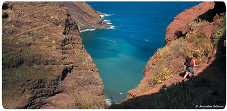
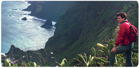
Vegetation changes with altitude and moisture. Ferns and laurel-forest species occupy the shaded ground; blue and white tajinastes, yellow aeoniums, reddish sorrel, palms, dragon trees and prickly pears appear where the slopes become warmer and more open. Clearings suddenly reveal the lonely cliffs and Atlantic below.
From Don Pedro across Barranco de Fagundo
The classic linear walk followed narrow paths through Barranco Magdalena to Don Pedro. Springs, dense undergrowth and an old wash place recall the daily life of local farming women: while clothes dried, they embroidered, cut goat fodder and exchanged news. Below the hamlet, the landscape gradually opens towards the coast.
El Tablado looks close from the Don Pedro viewpoint, but the immense Barranco de Fagundo drops almost to sea level between them. The old royal path then climbs the opposite wall in tight zigzags, regaining roughly 300 metres. For centuries it was the only link between these coastal settlements, and grain, potatoes and other loads had to be carried laboriously across the ravine.
El Tablado, a hamlet between two ravines
El Tablado lies within the Guelguén Special Nature Reserve between two of the island’s largest ravines: Fagundo separates it from Don Pedro and Barranco de Los Hombres from Franceses. Laurel forest and humid thermophilous woodland descend towards spectacular cliffs, with traditional northern houses scattered across the ridges.
Isolation has shaped village life. Many younger residents left and farming activity declined, yet old houses, gardens and terraces still reveal its past. El Tablado is not a tourist exhibit but a small inhabited community, so visitors should respect private property and should not assume shops or places to eat will always be open.
Important: the classic section is closed
The historic description covered a linear walk of around twelve kilometres, taking approximately six hours with about 350 metres of ascent and 900 metres of descent. The Don Pedro–El Tablado section forms part of the GR-130 and is demanding: very deep ravines, steep counter-climbs, poor mobile coverage and a complicated return journey require experience and careful transport planning.
The GR-130 is currently closed between Don Pedro and El Tablado because of rockfalls. The closure must be respected: do not attempt to bypass it or cross Barranco de Fagundo at your own risk. Before any walk, check the latest island trail status.
One marked option currently listed as open for reaching El Tablado is the PR LP 09.1 from Roque del Faro. The full circular route is 18.4 kilometres, takes about five hours and gains more than 1,000 metres; despite its medium rating, it requires good fitness. Current notices and waymarking always take precedence.